Monday, 17 December 2012

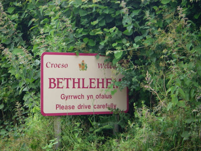
Bethlehem in Wales

Bethlehem in Wales
© Copyright Alan Bowring
Yes, we have a Bethlehem in Britain. It's a hamlet in south-west Wales and gets its name from the non-conformist chapel there. Not surprisingly it attracts a lot of tourists at Christmas time, all eager to get a Bethlehem postmark on their Christmas cards! Every year, a Christmas market is held in the hamlet.

Good walking country
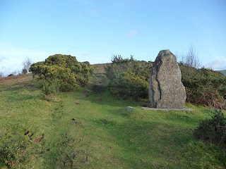
The path up Carn Goch, hear Bethlehem in Wales
The path up Carn Goch near Bethlehem
© Copyright Jeremy Bolwell
The terrain of the Welsh Bethlehem could not be more different from that of its Middle East counterpart. It lies in one of the remotest parts of the Brecon Beacons, a range of old red sandstone peaks to the south of Brecon (in Carmarthenshire). It's an area that is very popular with walkers. The hamlet itself is overlooked by Carn Goch, an iron-age hill fort, which sits on open access land and is therefore freely accessible to the public.

The Beacons Way, which starts in Bethlehem, runs west-east over the hill.


Posted by Louise Lambert

Thursday, 13 December 2012

Braemar: The Coldest Place in Britain

Braemar, the coldest place in Great Britain
Braemar, the coldest place in Britain
© Copyright Paul Chapman
We don't get really cold weather in Britain - not compared to other places around the world. But we do get 'big freezes' from time to time. Scotland usually sees the worst of the snow and ice, and the small town of Braemar in the Scottish Highlands has twice recorded the lowest ever temperature anywhere in Britain of 27.2 degrees C. By our standards that's pretty freezing and way below our usual winter lows. Braemar is also the coldest place overall in Britain with an average annual temperature of just 6.5 degrees C.  

Braemar is one of the highest towns in Britain at 1112 ft (339 m), and lies within the Cairngorms National Park. This is one of the most remote areas of the country and it's here that you'll find our highest mountains, also known as 'Munros', the name given to mountains over 3000 ft (914.4 m).

Glenshee Ski Centre, a 10 minute drive from Braemar, is Scotland's largest winter resort. The area is also popular with rock climbers. And every year on the first Saturday in September tourists and locals alike flock to the Braemar Gathering to watch the annual highland games. Members of the British Royal family have been attending 'The Games' (as the gathering is known), for generations.

To read more about skiing in Scotland click here

Photograph licensed for reuse under this Creative Commons Licence.

Tuesday, 4 December 2012

Walking Hadrian's Wall

Hadrian's Wall, Northern England
Hadrian's Wall
© Copyright David Dixon
Back in AD 122, when much of Britain was part of the Roman Empire, Emperor Hadrian ordered his soldiers to build a wall to keep the people of Scotland out. The wall stretched from the Tyne on the east coast to the Solway Firth in the west and was 80 Roman miles (about 73 modern miles) long, 8-10 feet wide, and 15 feet high. Small forts called milecastles were also built every Roman mile along the wall's length, with towers every 1/3 mile. Sixteen larger forts holding from 500 to 1000 troops were built into the wall, with large gates on the north face. To the south of the wall the Romans dug a wide ditch, (vallum), with six foot high earth banks. The entire construction took around six years to complete.

Birdoswalk Fort, Hadrian's Wall, Northern England
Birdoswald Fort, Hadrian's Wall
© Copyright David Dixon
Hadrian's Wall today
Thanks to extensive preservation and restoration work, a significant portion of the wall still exists and in 1987 it was made a UNESCO World Heritage Site. English Heritage, a government organisation in charge of managing the historic environment of England, describes it as 'the most important monument built by the Romans in Britain'. It is now a very popular tourist attraction and can be followed for much of its length on foot (along Hadrian's Wall Path) or by cycle (on National Cycle Route 72).

Hadrian’s Wall Path
So called because it follows Hadrian's Wall for most of its length, this long distance path  (135 km / 84 miles) runs from Wallsend on the east coast of England to Bowness-on-Solway on the west coast. The walking is relatively easy, that is to say more or less flat, although muddy in places. The highest point on the path is only 345 metres (1130 feet) high. Though most of the Wall runs through remote countryside featuring rolling fields and rugged moorland, there are sections which pass through the cities and suburbs of Newcastle and Carlisle. The section between Chollerford and Walton is the highest and wildest part of the path; it is also where the Wall is most visible, and includes several important Roman forts.

The path is well signposted and there are many interesting places to visit along the way.

For more information about Hadrian's Wall, click here.

The photographs used in this post are licensed for reuse under this Creative Commons Licence.
Saturday, 24 November 2012

Sandringham House: A Royal Retreat


Sandringham House
© Elwyn Thomas Roddick
Sandringham House, in Norfolk, has been privately owned by the British Royal Family for four generations. Built in 1870 by the Prince and Princess of Wales (later King Edward VII and Queen Alexandra), it lies within the Royal Sandringham Estate - 8,000 hectares (20,000 acres) of land near the village of Sandringham.

Sandringham House is a regular and favourite country retreat of the Queen and the Duke of Edinburgh, who spend every Christmas there surrounded by other members of the royal family. On Christmas morning hundreds of royal fans gather to get a glimpse of the family members as they attend the service at the small church that lies on the estate. Last Christmas (2011) was the first Christmas together as a married couple for the Duke and Duchess of Cambridge (aka Prince William and Kate Middleton) - see picture below.

Duke and Duchess of Cambridge, Christmas Day 2011
Christmas Day 2011
© Richard Humphrey
In 1968 part of the Sandringham Estate was designated a Country Park. Today nearly 243 hectares are freely open to the public

The Sandringham House gardens were opened to the public by King Edward VII in 1908, and the Museum (which has displays of royal life and the estate's history) by King George V in 1930. Sandringham House itself was opened to the public at the Queen's wish in 1977, her Silver Jubilee year.

The Royal Sandringham Estate lies within the Norfolk Coast Area of Outstanding Natural Beauty.

For more information about Sandringham House and the Sandingham Estate click here

The photographs used in this blog licensed for reuse under this Creative Commons Licence

Sunday, 18 November 2012

Stonehenge: Landmark of Mystery


© Copyright Peter Trimming
Stonehenge in Wiltshire is a World Heritage Site and one of Britain's most striking landmarks. Standing just off the A344 near Salisbury (and quite visible from the road), this prehistoric monument is thought to have been constructed between 3000 BC to 1600 BC. Its original purpose is still something of a mystery. Possible explanations are that it was a temple for sun worship, a healing centre, a burial site or perhaps a huge calendar.

Evidence of the peoples who built Stonehenge exists through their tools, artefacts, pottery and even the contents of their graves. Some of these are displayed in the museums at Salisbury and Devizes.


© Copyright Peter Trimming

Stonehenge attracts visitors all year round, and many people report powerful energies at the site. For neopagans, druids and new age devotees it is a place of pilgrimage and worship.

On the summer and winter solstices (21st June and 21st December) literally thousands of people gather before daybreak to see the sun rising above the stones. Although the summer solstice celebrations attract more public attention, it is thought that the winter solstice was actually more important to the people who constructed Stonehenge. The winter solstice was a time when most cattle were slaughtered (so they would not have to be fed during the winter) and the majority of wine and beer was finally fermented.

Click here for more information about Stonehenge, including how it was built

Click here to browse books about Stonehenge

The photographs used in this blog licensed for reuse under this Creative Commons Licence